New Views on the Nature of the Malguzar Dike Belt (Southern Tien-Shan)
Introduction
The Malguzar dike belt is about 700 km long and 20-40 km wide. The main zone is Nuratau-Turkestan (Zarmitan-Malguzar- Shahristan-Sabah-Arpapayat direction within the Turkestan-Alai, Zarafshan-Turkestan structural-facies zones) and a less powerful zone is located to the south - in the Zarafshan-Alai (Zarafshan- Gissar) zone, Ziaetdy -Anzob-Margib-Rufigar direction. With the predominance of large (up to 0.3x8 km2) gabbro-dolerite sills and dikes, there are small necks (tens of meters) and explosive bodies of basalt tuffites and tholeiite basalts (spilites). The latter are reliably established in the southern belt and in the Zarafshan-Turkestan zone of the northern belt [1,2]. Dikes and small intrusions of the belt are common in the mountains of Malguzar, Northern and Southern Nuratau, Karakchatau, Gobduntau, Marzhanbulak, Karatau, Auminzatau, etc. [3-7]. According to V.V. Baranov [3], gabbro-diabase small intrusions are found in Auminzatau (Zahkuduk, Dzhetymtau outcrops), Northern Nuratau (sites Baipurushli, Yukarysaray, Pistalitau, Ukhum, etc.), but they are especially widely developed in the Malguzar mountains and northern slopes of the Turkestan Range, where they form two bands (northern and southern) of sublatitudinal strike. The most clearly distinguished is the North Malguzar strip, traced for 180 km. It reaches its maximum width (10-12 km) in the Zaaminsu interfluve (in the west) - Altynkolsay (in the east). The most saturated band with a width of up to 15 km and a length of more than 150 km can be traced along the northern slopes of the Malguzar Mountains and the North Nurata Range.
Geological Structure
The Malguzar Mountains have a complex cover-scaly and block structure. The Malguzar Mountains are a southeastern continuation of the North Nurata Range, stretching in a southeast direction for 100 km from the Sanzar Riverbed to the junction with the Turkestan Range, their width is from 20 km to 35 km, and an area of about 2500 km2 (Figure 1). The ridge is composed of a sequence of Lower and Middle Paleozoic terrigenous-carbonate deposits. Stratified formations are represented by carbonate and terrigenous-carbonate formations, as well as carbonate formations of the Karasu-Myk strip, displaced in the processes of thrust formation and shaping. Contacts between stratified units are everywhere tectonic. Among the great variety, subvolcanic tholeiitic gabbro-dolerite dike formations are of particular interest, which form the Malguzar dike belt about 700km long and 20-40km wide, with which late magmatic segregation ilmenite and titanomagnetite mineralization of a small scale are genetically associated.
With the predominance of large (up to 0.3x8 km2) gabbrodolerite sills and dikes, there are small necks (tens of meters) and explosive bodies of basalt tuffites and tholeiitic basalts (Figure 1). The latter are reliably established in the southern zone and in the Zarafshan-Turkestan zone of the northern zone. Acid differentiates of the dike belt in the Malguzar mountains are much less common than the main ones. They form stock-like and dikeshaped bodies of diorites, quartz diorites, granodiorite porphyries, granite porphyries, and quartz porphyries and lamprophyres, the latter are widespread in the betrayals of the Koytash and Karatau mountains [8,9]. Small stocks and dykes of diorites, microdiorites, quartz diorites, diorite-porphyrites are found in Myksai, Saibeksai, and Bash-Pshagar. In the last section, they occupy an area of about 1.5x3 km. The rarest in the Malguzar complex are small dikes and stock-like bodies (up to 25x40 m) of granite-porphyry, established in the mountains of Malguzar and Karatau (Sarmich stock), on the Gobduntau and Mardzhanbulak uplands.
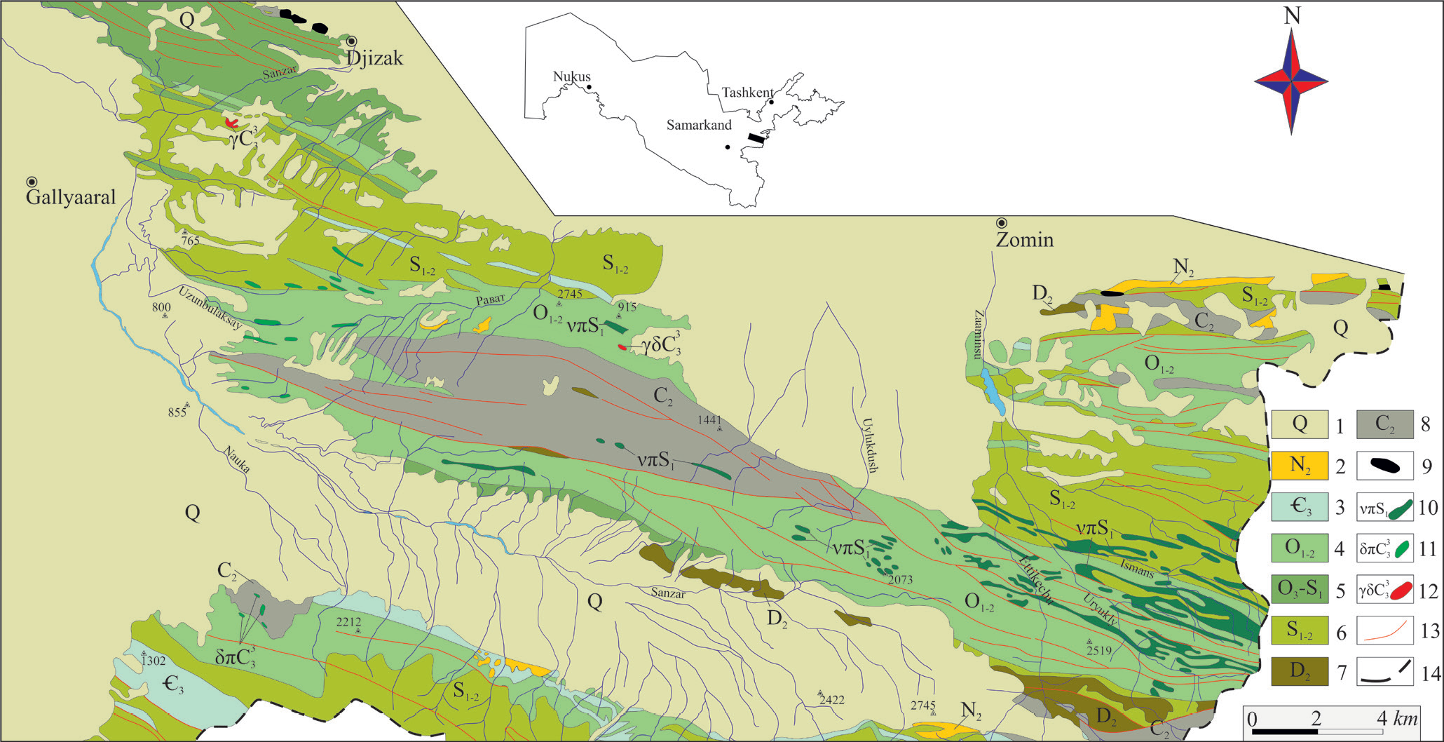
Figure 1: New views on the nature of the Malguzar dike belt (Southern Tien-Shan).
Note: Schematic geological map of the Malguzar Mountains (according to S.T. Maripova et al., 2015). 1 - Quaternary deposits, 2 - Neogene deposits, 3-6 - siliceous-carbonate-sandy-shale and sandy-shale strata Є3, O1-2, O3-S1, S1-2, 7 - brecciated light gray limestones with lenticular interlayers and concretions of siliceous rocks, 8 – interbedding of dark gray organogenic-clastic limestones with argillaceous-ferruginous calcareous mudstones and lenticular interlayers of black cherts, 9 – remnants of hypermafic protrusions, 10 – sills and dikes of gabbro-dolerites, diabases, 11 – small diorite intrusions, diorite porphyrites, 12 - small intrusions of granite, granodiorite-porphyry, 13 - faults, 14 - state border with Tajikistan.
Discussion and Conclusion
The presented material, despite its fragmentation, allows us to make a number of general considerations. First, based on the analysis of the petrofund of this association and the compositional features of the rocks, it is advisable to retain the name “gabbrodolerite- granitoid complex” for it. Secondly, the presence of small intrusions of gabbro-diabases, diorites, and granite-porphyries in the continuation of the dike belt, in all likelihood, is part of the complex; thirdly, the discovery of volcanic analogs in the eastern part indicates that the sequence is eroded from east to west; fourthly, they mark extended igneous zones controlled by deep faults as Zarafshan and Severo Nurata, accompanied by bands of development of Riphean-Early Paleozoic sedimentarymetamorphic deposits. Summarizing the above, it can be noted that the formation of rocks of the gabbro-dolerite-granitoid complex occurred from the second half of the Silurian period to the Upper Carboniferous-Lower Permian. At the initial stage, the area was a rift structure [10] of early consolidation with the manifestation of tholeiite basalts, followed by the migration of gabbro-dolerite chambers through dioritoids to felsic components. The evolution of tholeiitic magma, depending on the degree of its differentiation, caused the accumulation of titanium, iron, phosphorus, copper, and gold in it, which ultimately led to the metallogenic specialization of gabbro-diabases [11] into elements of the iron group (V, Mn, Cr, Ni, Co), and acid differentiates into lead, tungsten, gold, etc.
For more Articles on: https://biomedres01.blogspot.com/


No comments:
Post a Comment
Note: Only a member of this blog may post a comment.